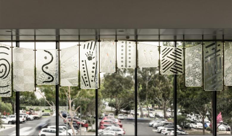
Let us walk together depicts aspects of the characteristics, history and development of the municipality.
The overall form of the panels is curved along the upper edge, which symbolises the rolling hills of the area visible to the north and east, while the staggered lower edge represents the city skyline and the municipality’s built environment.
- Panel 1 - water symbols represent the Birrarung, Mullum Mullum and Koonung Creeks
- Panel 2 - depicts windbreaks planted to protect the fruit trees
- Panels 3, 10 and 12 - tell of clearing the land, planting of crops and orchards and the early development of the suburbs
- Panel 4 - the lizard tracks symbolise animal life
- Panel 5 - rain and flooding has significantly impacted on the land and habitation
- Panel 6 - the coming together of artists at Heide
- Panel 7 - represents fire used to clear the land and the bushfires that have wreaked havoc
- Panel 8 - the body paint symbolises the dance performed at the meeting of the Kulin Nation
- Panel 9 - represents multiculturalism, unity and sense of community
- Panel 11 - the campsites or suburbs and the roads leading to and from Manningham
- Panel 13 - the x-ray image of an animal stomach represents the possum skin cloaks distinctive to First Nations people from southeast Australia
- Panel 14 - snake tracks.
To find out more about the commissioning of this artwork, view the video produced by Message Stick.
Scar Tree Shields
Scar trees have had their bark removed by First Nations people.
The removal of bark does not kill the tree but leaves a clearly visible and generally symmetrical scar. The symmetry of the scar is one way of telling whether the scar was caused by human action rather than of natural causes. Scars can range in length from thirty centimetres to five metres. The size of the scar provides a clue as to whether the bark was used for a container, shield, a canoe or a slab for making a shelter.
There are a number of scar trees in the area of the Bolin Bolin Swamp along the Birrarung.
This work was commissioned to celebrate the Centenary of Federation and the building of the City’s Function Centre. It was supported by the Federal Government through the Federation Community Projects Fund.
Location of artwork
- Level 2, Manningham Civic Centre, 699 Doncaster Road, Doncaster VIC 3108
- View on map
About the artists
In 1998 Wathaurong Glass was formed to express Aboriginal art in glass. The techniques used to produce their products include the use of kiln forming (slumping glass), sandblasting or any other technique they feel is suitable to achieve the desired result.
The name “WATHAURONG” (wathawurrung or wadda wurrung) is a recognised tribe, it consisted of 25 groups (clans). The boundaries of Wathaurong are from Geelong, north to Werribee River, northwest to Bacchus Marsh, south west to Cressy, south east to Colac, east to Lorne and north back to Geelong, encompassing the Bellarine Peninsula.
Learn more about Wathaurong Glass
- Website - Wathaurong Glass and Arts