Meeting Date: 28 March 2023
Meeting Time: 7.00pm
Location: Council Chamber, Civic Centre 699 Doncaster Road, Doncaster.
Displaying 41 - 52 of 52
… Staff Service Awards 6:20 5.2 Victoria Police Honours and Awards Ceremony 6. PETITIONS 8:05 6.1 Request to Cease … Development Plan 36:00 11.2 Draft Aquarena Aquatic and Leisure Centre Outdoor Masterplan 12. CITY SERVICES … Strategic Property Acquisition Policy 13. EXPERIENCE AND CAPABILITY 55:28 13.1 State Government Advocacy Update …
Council meeting livestream
Time stamps
| Time Code | Item |
|---|---|
| 4:35 | 5. PRESENTATIONS |
| 4:45 | 5.1 Manningham Staff Service Awards |
| 6:20 | 5.2 Victoria Police Honours and Awards Ceremony |
| 6. PETITIONS | |
| 8:05 | 6.1 Request to Cease Plans to Build a Footpath along Unwin Street, Templestowe |
| 8:50 | 7. PUBLIC QUESTION TIME |
| 26:45 | 8. ADMISSION OF URGENT BUSINESS |
| 25:51 | 9. PLANNING PERMIT APPLICATIONS |
| 26:05 | 10. CITY PLANNING |
| 27:10 | 11. CONNECTED COMMUNITIES |
| 27:10 | 11.1 Sports Facility Development Plan |
| 36:00 | 11.2 Draft Aquarena Aquatic and Leisure Centre Outdoor Masterplan |
| 12. CITY SERVICES | |
| 44:04 | 12.1 Draft Strategic Property Acquisition Policy |
| 13. EXPERIENCE AND CAPABILITY | |
| 55:28 | 13.1 State Government Advocacy Update |
| 1:06:55 | 13.2 MAV State Council 2023 - Cost of Living Motions |
| 14. CHIEF EXECUTIVE OFFICER | |
| 1:13:08 | 14.1 Appointment of Authorised Officer - Planning and Environment Act 1987 |
| 1:13:40 | 14.2 Informal Meeting of Councillors |
| 1:13:10 | 14.3 Documents for Sealing |
| 1:14:50 | 15. URGENT BUSINESS |
| 1:15:00 | 16. COUNCILLOR REPORTS AND QUESTION TIME |
Get involved at our next council meeting
… Local Law 2023 47:23 10.3 New Committees - Liveable Places and Spaces Advisory Committee (LPSAC) and Historical Societies Working Group (HSWG) - Endorse Terms … 2023 Capital Works Status Report 57:10 13. EXPERIENCE AND CAPABILITY 57:15 13.1 Manningham Quarterly Report, …
Meeting Date: 30 May 2023
Meeting Time: 7.00pm
Location: Council Chamber, Civic Centre 699 Doncaster Road, Doncaster.
Council meeting livestream
Time Stamps
| Timecode | Item |
|---|---|
| 4.25 | 5. PRESENTATIONS |
| 4:33 | 6. PETITIONS |
| 4:38 | 6.1 Parking restrictions in Rose Street Doncaster |
| 5:28 | 6.2 Footpath construction in Carlton Court, Templestowe |
| 6:07 | 7. PUBLIC QUESTION TIME |
| 13:07 | 8. ADMISSION OF URGENT BUSINESS |
| 13:17 | 9. PLANNING PERMIT APPLICATIONS |
| 13:20 | 9.1 Planning application PLA22/0031 for an amendment to Planning Permit PL 14/024793 at 1026-1030 Doncaster Road, Doncaster East |
| 22:58 | 10. CITY PLANNING |
| 23:05 | 10.1 Shopping Centre Upgrade Plan |
| 33:35 | 10.2 Community Local Law 2023 |
| 47:23 | 10.3 New Committees - Liveable Places and Spaces Advisory Committee (LPSAC) and Historical Societies Working Group (HSWG) - Endorse Terms of Reference |
| 52:11 | 11. CONNECTED COMMUNITIES |
| 52:17 | 12. CITY SERVICES |
| 52.20 | 12.1 March 2023 Capital Works Status Report |
| 57:10 | 13. EXPERIENCE AND CAPABILITY |
| 57:15 | 13.1 Manningham Quarterly Report, Quarter 3 (January-March), 202/23 |
| 1:01:35 | 14. CHIEF EXECUTIVE OFFICER |
| 1:01:40 | 14.1 Proposed 10 year Financial Plan 2023/24 to 2032/33 |
| 1:07:46 | 14.2 Proposed 2023/24 Budget |
| 1:22:50 | 14.3 Informal Meeting of Councillors |
| 1:23:25 | 14.4 Documents for Sealing |
| 1:23:50 | 15. NOTICES OF MOTION |
| 1:23:55 | 15.1 Notice of Motion by Cr Tomas Lightbody (NOM No. 2/2023) |
| 1:25:46 | 16. URGENT BUSINESS |
| 1:23:53 | 17. COUNCILLORS REPORTS AND QUESTION TIME |
| 1:39:55 | 18. CONFIDENTIAL REPORTS |
Get involved at our next council meeting
… which will connect the Metropolitan ring road (M80) and Eastern Freeway (M3), as well as: the completion of the … Contact us About Council North East Link Advocacy Parking, Roads and Footpaths Property and Development … North East Link …
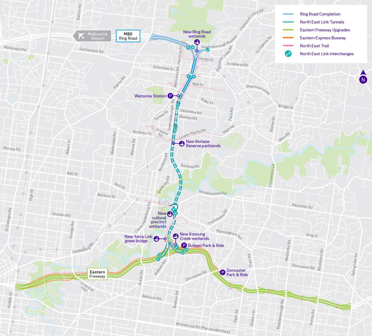
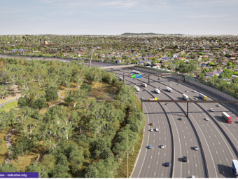
The State Government has now commenced works for the North East Link Program (NELP).
The project will include construction of the North East Link Tunnels, which will connect the Metropolitan ring road (M80) and Eastern Freeway (M3), as well as:
- the completion of the Ring Road in Greensborough
- an overhaul the Eastern Freeway
- Melbourne’s first dedicated busway
- the North East Trail – more than 34km of walking and cycling paths.
North East Link is split into five construction packages, with the following three located in Manningham:
- Central/tunnels
- South
- East
Council is continuing to work diligently alongside North East Link Program and State Government on all aspects of the project.
We’re committed to representing community interests with the aim of mitigating impacts, as far practicable, to the community.
We’re committed to representing community interests with the aim of mitigating impacts, as far practicable, to the community.
Related Links
Related North East Link news
Sports and recreation
Bulleen Park
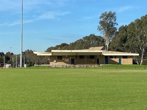
Bulleen Park is being upgraded to support sporting clubs during the construction of North East Link.
Future redevelopment of Bulleen Park will allow for continued use of the sporting and recreation facilities during the delivery and following the completion of the North East Link Program (NELP).
The redevelopment will result in a major upgrade to the football (AFL) and cricket facilities and include:
- two new replacement pavilions
- realignment and redevelopment of the three existing sports ovals
- upgrades to sports field lighting, cricket nets, and fencing
- planting of new trees and vegetation
- upgrading playground equipment and park amenities
- reconfigured car parking.
The project is expected to be completed by 2028. During this period, NELP will continue to provide user groups with construction updates to keep the community informed of progress and milestones.
Bulleen Park FAQs for sporting clubs, March 2024
Soccer facilities on Templestowe Road
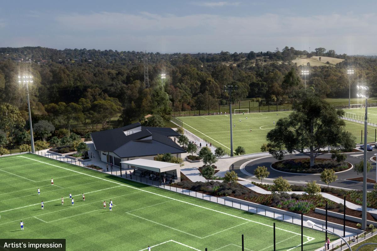
To compensate for loss of two existing soccer pitches and open space at Bulleen Park, Development Victoria will deliver a new sporting precinct at 27-59 Templestowe Road, Bulleen as part of the North East Link Program.
The new sporting facility will include:
- three soccer fields (2 natural turf and 1 synthetic pitch)
- a sports pavilion with tiered seating and changing, umpire and first aid amenities
- 176 car park spaces
- a playground area; and,
- walking and cycling connections to the Yarra River.
Soccer facilities at Templestowe Road FAQs, December 2023
Park and Ride
Doncaster Park and Ride
Doncaster Park and Ride will be upgraded as part of NELP. We are advocating that the Doncaster Busway (including the Bulleen Park and Ride) be designed to operate and function as part of a network-wide Bus Rapid Transit system. This is beyond the busway corridor that is proposed along the Eastern Freeway between Hoddle Street and Doncaster Road.
We are also advocating for the State Government and NELP to amend the NELP Doncaster Park and Ride reference design to a mixed-use transit-oriented development.
At this stage the State Government has only committed to a like for like upgrade, which will result in the reconstruction of the Park and Ride to be retained as a carpark only.
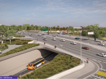
Bulleen Park and Ride
Bulleen Park and Ride is now open. The new bus station on the corner of Thompsons Road and Kampman Street in Bulleen is the first part of the Eastern Express Busway – Melbourne's first dedicated busway from Doncaster towards the city and features:
- parking for 370 cars
- bike storage
- pick-up and drop-off bays
- a 5000 square metre green roof.
Templestowe Road
We have successfully negotiated for the Victorian Government to commence detailed planning work and a business case for the duplication and upgrade of Templestowe Road (from Bridge Street to Thompsons Road). This will include shared pedestrian and bike paths along the north side.
Environment
Tree planting
NELP will plant two replacement trees for every tree removed during construction of the project.
A key objective for Council is to ensure that the loss of tree canopy and vegetation is minimised and mitigated. We're working closely with NELP to identify appropriate locations for early tree planting to occur to allow the new canopy to establish. Some early planting has already occurred across various locations in Manningham, including Katrina Reserve (Doncaster) and Finns Reserve (Lower Templestowe).
Council has planted more than 500 trees since 2022 within various reserves in Manningham on behalf of NELP. We will continue to support the early planting program.
River Red Gum, Bulleen
The historic 300 year old River Red Gum on Bridge Street in Bulleen is in close proximity to major North East Link works and must be protected. This tree is a local landmark, pre-dates European settlement and is an important example of our environmental heritage.
We will continue to regularly attend when works are being undertaken near the tree to ensure that appropriate mitigation measures are undertaken.
Air quality and noise
We are continuing to advocate to NELP and other State authorities to ensure that all appropriate measures are taken to mitigate the air quality impacts of the project on the health and wellbeing of the local community.
We are also working closely with NELP to ensure that noise associated with construction is mitigated as far as practicable. Any noise emitting works that may exceed noise levels are also planned to occur either during the day or early in the night, as far as practicable. Affected residents are also notified prior to the works that noise may occur during a time period with a direct NELP contact provided to them to call where concerns are raised.
Get in touch about the NELP
… at Parker Street, Templestowe On this page Paths and Trails Parking, Roads and Footpaths Roads and footpaths … Footpath construction: Parker …
Article Content
Connecting our community through safe footpaths is one of the ways we’re building a better Manningham.
As part of our 2024/25 Capital Works Program, we’re building a footpath along Parker Street between Milne Street and McLachlan Street to better connect residents and the broader community to the shops and facilites at Templestowe Village. This will also include kerb and channel and roadside drainage.
Where is it?
We’re building a footpath along Parker Street between Milne Street and McLachlan Street, Templestowe.
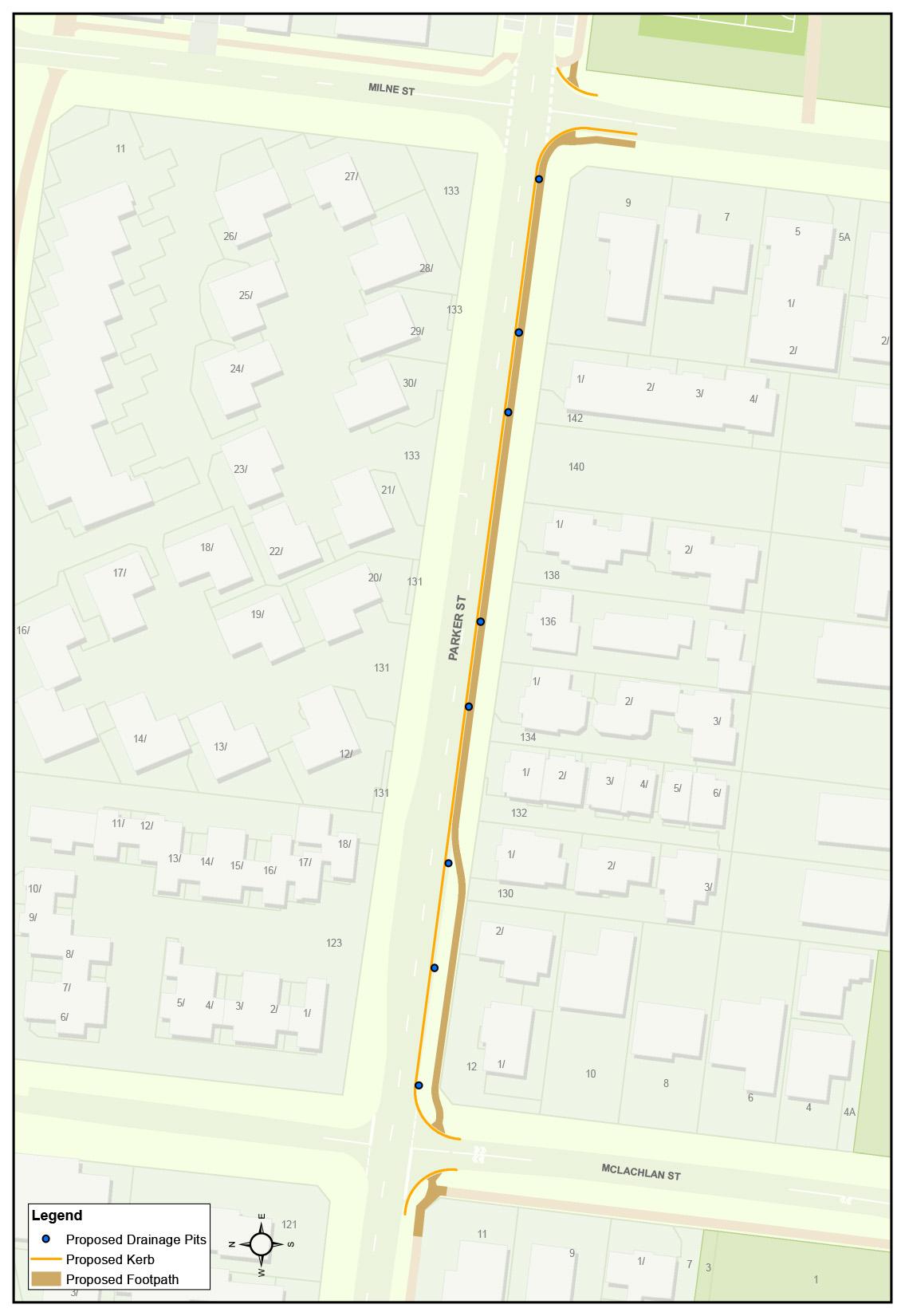
Why is the footpath needed?
There is no current path, with uneven terrain alongside the road. This is a particularly steep slope making pedestrian movement currently difficult. Building this path will better connect residents and the broader community to the shops and facilites at Templestowe Village.
When will the works happen?
Works will begin in late May 2024, taking around nine weeks to complete.
Project dates are subject to change due to programming with our contractors and weather
How will the works affect me?
- Construction noise from machinery and workers
- temporary disruptions to on-street parking
- Temporary disruptions to driveway access - we will contact affected residents directly.
We will make every effort to minimise disruptions during construction.
Questions?
If you have any questions about these works or our footpaths program, contact us.
… Footpath and pedestrian crossing construction: Foote Street, … Templestowe. On this page Paths and Trails Parking, Roads and Footpaths Roads and footpaths … Footpath and pedestrian …
Article Content
Connecting our community through safe footpaths is one of the ways we’re building a better Manningham.
As part of our 2023/24 Capital Works Program, we’re improving the footpath connection for Ruffey Creek Trail at Foote Street, Templestowe.
The works will involve:
- relocating the current crossing to the eastern side of the intersection
- installing pedestrian-operated signals, traffic island fencing, road markings and signage.
- footpath widening
- upgrades to street lighting.
Where is it?
We are upgrading the pedestrian crossing at the Foote Street and McLachlan Street intersection. Works will occur on Foote Street and the footpaths of Foote Street, McLachlan Street and Ruffey Creek Trail.
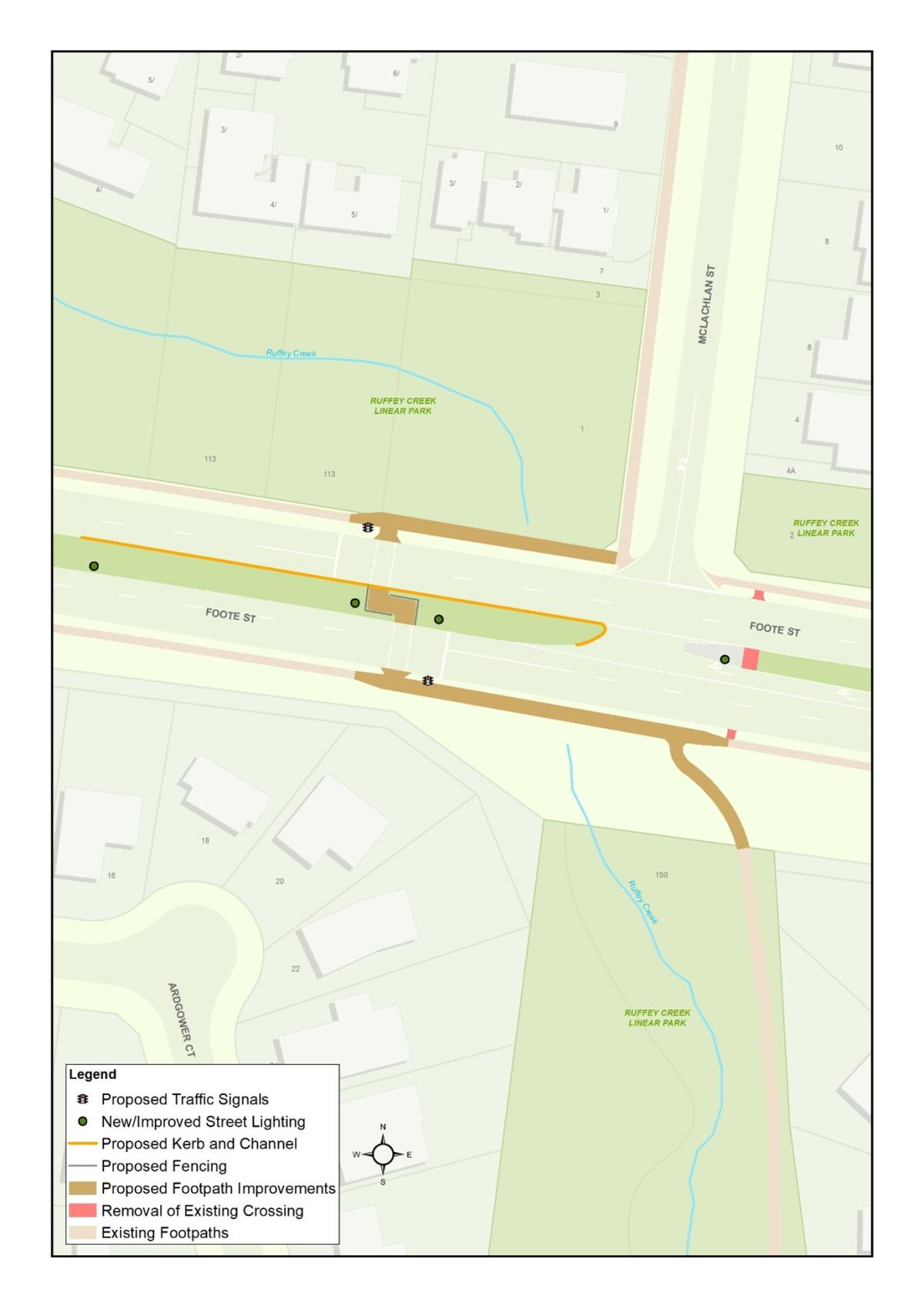
Why are these works needed?
These works will create a safer and more accessible footpath connection for pedestrians and Ruffey Creek Trail users.
When will the works happen?
Works are scheduled to begin in March and will likely be completed in July 2024, subject to weather conditions.
How will the works affect me?
Construction works will occur on weekdays, between 7.00am and 5.00pm. You may notice construction noise, footpath closures and minor traffic delays during these times. To complete the works safely, we’ll need to close one lane of Foote Street. We don’t anticipate any disruption to property access.
We will have traffic management and signage on site to guide you through the area.
We appreciate your patience and understanding while we work to improve the footpath connections in your area.
Questions?
Please contact us if you have any questions about these works or our footpaths program.
… upgrade will enhance safety, pedestrian connectivity, and infrastructure quality. On this page Parking, Roads and Footpaths Roads and footpaths … Templestowe Route upgrade …
Article Content
The Templestowe Route upgrade will include, road resurfacing, footpaths, underground drainage, kerb and channel and other improvements to enhance safety, pedestrian connectivity, and infrastructure quality.
Where is it?
The Templestowe Route is a series of important local link roads between Fitzsimons Lane and Templestowe Road. These roads provide access to local residents, Templestowe Village and connect traffic travelling to and from surrounding suburbs.
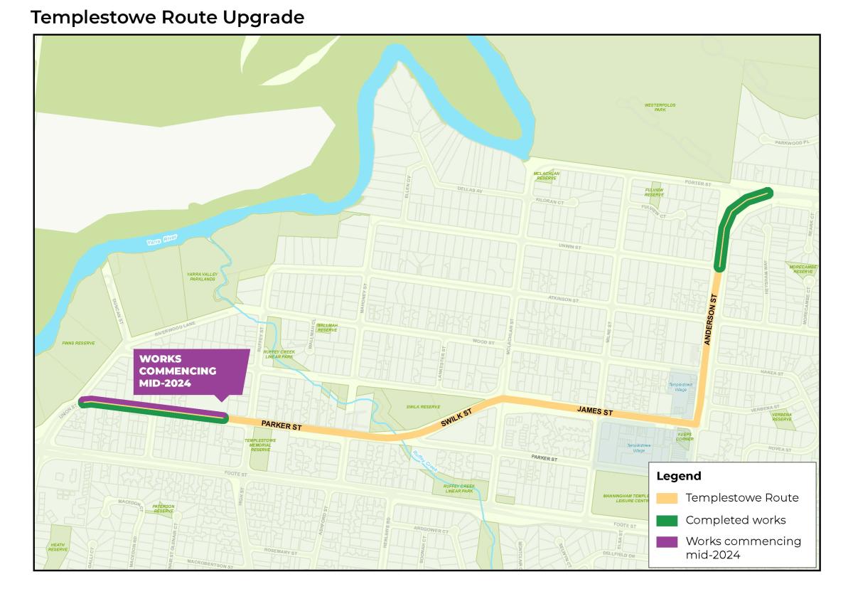
Why is the upgrade needed?
Several safety issues have been identified with Templestowe Route, including poor drainage and inadequate facilities for pedestrians and cyclists.
This project aims to:
- improve safety for all users, including motorists, cyclists and pedestrians
- address traffic and speeding concerns
- extend the lifespan of the road
- reduce drainage issues
- improve road and footpath longevity.
Find the latest project updates on Your Say Manningham. Subscribe to the project to receive updates directly in your inbox.
… Tram Road and Merlin Street intersection upgrade Find out more about … On this page Key Projects Doncaster Hill Parking, Roads and Footpaths Roads and footpaths … Tram Road and Merlin Street …
Article Content
Updated: 2 February 2024
We’re installing new traffic lights at the Tram Road and Merlin Street intersection to improve safety and traffic flow.
Following our advocacy and funding for this project, the Department of Transport and Planning (VicRoads) will deliver these works in 2024.
For more information and the latest updates, go to Tram Road and Merlin Street intersection upgrade.
Where is it?
These works will be at the intersection of Tram Road and Merlin Street in Doncaster.
When is it happening?
Find the latest updates at Tram Road and Merlin Street intersection upgrade.
Why is it needed?
The goal of the signalised intersection is to ease traffic congestion in the southern part of Doncaster Hill, helping residents to access Tram Road easily while also ensuring a safer road environment for both drivers and pedestrians.
This project is part of our long-term planning for the future. It is a key project outlined in the Doncaster Hill Strategy 2002 (2004), which anticipated a substantial rise in population due to high-density residential housing in the area.
This project is funded by our 2023/24 Capital Works Program.
How will these works affect me?
Changes to on street parking
To allow for dedicated turning lanes out of Merlin Street, we need to remove five on-street car parks from Merlin Street (see map above). However, we have managed to minimise the loss by including two additional on-street parking spaces on Merlin Street in our design.
The parking restrictions for the car parks on the northern side of the street will be changed to ‘2P (resident permit exempted) from 8.00pm to 8.00am – no stopping at all other times’.
We will also need to remove two car parks from Tram Road service road to allow for a pedestrian crossing from the traffic lights. Unfortunately, there is no available space in this area to offset the loss of these car parks.
We understand that the parking changes on Merlin Street might concern those who frequently park there. We assure you that we're doing our best to deliver a solution that meets the needs of local residents and keeps drivers and pedestrians safe.
Construction impacts
The Victorian Department of Transport and Planning will provide information about any construction impacts closer to the date.
Questions?
If you have any questions, please contact us on 9840 9333 or at manningham@manningham.vic.gov.au.
… look at the latest footpath upgrades coming to Warrandyte and Wonga Park We’re holding two consultation sessions for … and Wonga Park in 2024. On this page All News Parking, Roads and Footpaths … Take a look at the latest footpath upgrades …
Article Content
We’re holding two consultation sessions for footpath upgrades in Warrandyte and Wonga Park. Residents can drop in to review plans, ask questions, and provide feedback on five footpath upgrades coming to Warrandyte and Wonga Park in 2024.
The first session will be held at Warrandyte Community Hall on Wednesday, 29 November, from 4.00pm to 8.00pm. The second session will take place at Wonga Park Hall on Tuesday, 5 December, from 4.00pm to 8.00pm.
Both sessions will cover five footpath upgrades: Yarra Road, Dudley Road, Pound Road and the Main Yara Trail extension.
About the footpaths
The footpath upgrade for Yarra Road (368 to Homestead Road) and Dudley Road (property 3 to Wonga Park Primary School) are identified in the Manningham Principal Pedestrian Network and will connect residents to primary locations.
The footpath upgrade on Pound Road aims to address community concerns around the safety of pedestrians and children on the existing path, particularly in narrow sections of the road.
Following the completion of stage one in August 2023, we’re also excited to present the designs for stage three and four of the Main Yarra Trail extension project, which once finished, will complete the connection from Warrandyte to the CBD.
Design considerations
When we design footpath upgrades, we take into consideration how the footpath can protect and enhance its environment, while also acknowledging the unique characteristics of Warrandyte and Wonga Park. We aim to balance this with our responsibility to offer safe, accessible, and environmentally friendly infrastructure that everyone can use.
Although informal footpaths made of dirt, gravel or crushed rock are characteristic of these suburbs, we have heard from the community about their concerns around safety and accessibility, particularly for those using prams or wheelchairs. Gravel and crushed rock paths have high maintenance and environmental costs.
The upgrades are set to provide safer and more accessible walking paths for residents and the broader community. This consultation process is designed to ensure the paths meet the needs of local residents.
At these sessions, you can also ask us for updates on other infrastructure projects in Warrandyte and Wonga Park. These include planned drainage improvement works, such as Jumping Creek Road, Everard Drive, and Melbourne Hill Road.
… consultation for upcoming footpath projects in Warrandyte and Wonga Park Find out about the community feedback we … consultation sessions. On this page All News Parking, Roads and Footpaths … Wrapping up our consultation for upcoming …
Article Content
Over 50 residents attended our December consultation sessions to review project plans, ask questions and provide feedback on upcoming footpath projects in Warrandyte and Wonga Park.
The discussions were insightful, providing us the opportunity to speak face-to-face with the community to hear their experiences and concerns, and allowing us to discuss the objectives and benefits of the proposed projects.
The key topics that were raised across all projects were:
- Protection of the environment
We discussed the benefits of designated paths, which prevent people from trampling on vegetation to create new paths. When designing new paths, we do our best to navigate existing vegetation and trees. - Material types
Many attendees expressed their preference for softer path surfaces in these suburbs. We strive to balance this preference with our responsibility to provide safe, accessible and environmentally friendly infrastructure. For example, gravel and crushed rock are not suitable for paths with steeper slopes as the surface will erode over time, often causing environmental and safety issues. Residents can read the Green Wedge Guide to see how we select materials that best work with the natural environment. - Project drivers and rationale
We received several questions about how our projects were chosen.
Many of our footpath projects are derived from community requests and feedback. Although we have strategies in place, such as the Manningham Bicycle Strategy, hearing from the community at consultations like this one is critical in helping us shape and prioritise our projects.
Here's some more information about the project-specific discussions we had.
Pound Road, Warrandyte
Why are we doing this?
This project responds to community requests for a safe and accessible path down the road, allowing pedestrians and people with prams or wheelchairs to actively travel around the area.
After considering your feedback, we will now deliver this upgrade in two stages. The first stage will be from Diane court to the Warrandyte State Park, likely beginning in March 2024. For the second stage, from Heidelberg-Warrandyte Road to Diane Court, we will share the final design with the community once it is completed, before proceeding with the project construction.
Why use solid materials (concrete/asphalt)?
You told us you’d like us to minimise hard surfaces. So, around 70 per cent of this footpath will be made of gravel and crushed rock. We will only construct the footpath using asphalt in sections at higher risk of erosion or washing onto the road. Also following your feedback, we’ll trial stone kerbs for sections along the roadside to better blend with the natural environment.
How will you protect trees and the environment in this area?
A designated footpath prevents people from treading on grasses, shrubs and trees to create a path.
Taroona Avenue (section four of the Main Yarra Trail), Warrandyte
Why are we doing this?
The project was initiated by community requests for a safe and accessible path that will allow pedestrians and cyclists to use the less busy road. This section will also complete the Main Yarra Trail.
Why solid materials (concrete/asphalt)?
As this area receives high foot traffic, a solid surface will provide a more durable, low-maintenance solution. However, in response to your feedback, we have reduced the path size from the proposed shared path, down to a footpath.
What kerb type will be used?
You asked us to use materials that better blend with the environment. So, this project will trial a section of stone kerb.
Main Yarra Trail extension (Pound Road to Taroona Avenue), Warrandyte
Why are we doing this?
This is connection of the Main Yarra Trail will provide a link for active commuters from Melbourne’s CBD to Warrandyte. A shared path will be safer allowing for recreational cyclists to ride without interacting with main road traffic.
Why along Heidelburg-Warrandyte Road?
We have explored various alternate routes, but the chosen path on the south side of the main road was the best option due to the terrain and non-straightforward connection (diverting down smaller residential streets).
What about guardrail/fencing?
In response to feedback about guardrails and fencing, we’ll discuss this further with the Department of Transport and Planning, as they are responsible for arterial roads such as Heidelburg-Warrandyte Road. A road safety assessment will be completed as part of the design process to ensure that all safety elements are considered in the design.
Yarra Road, Wonga Park
Why are we doing this?
The footpaths on Yarra Road and Dudley Road will complete the existing footpath network, connecting the shops and sporting facilities to and from Jumping Creek Road to Homestead Road.
Why solid materials (concrete/asphalt)?
As this area receives high foot traffic, a solid surface will provide a more durable, low-maintenance solution.
Dudley Road, Wonga Park
Why are we doing this?
The footpaths on Yarra Road and Dudley Road will complete the existing footpath network, connecting the shops and sporting facilities to and from Jumping Creek Road to Homestead Road.
Why solid materials (concrete/asphalt)?
As this area receives high foot traffic, a solid surface will provide a more durable, low-maintenance solution.
The next public consultation sessions for upcoming Warrandyte and Wonga Park projects have been scheduled in May. We will provide further details closer to the time.
If you have any questions about these upgrades, contact us.
… at Melbourne Hill Road, Warrandyte. On this page Parking, Roads and Footpaths Drains … Drainage upgrade: Melbourne Hill Road, …
Article Content
For more information about this project, including project updates, please visit Your Say Manningham.
Improving drainage and flood mitigation is one of the ways we're building a better Manningham.
As part of our 2023-24 Capital Works Program, we're ugrading the drainage system at Melbourne Hill Road, Warrandyte to improve stormwater management and reduce flood risk.
Where is it?
The project area covers approximately 35 hectares of residential area along Melbourne Hill Road, Houghton Road, Francis Street, and Lorraine Avenue.
Why is the upgrade needed?
This upgrade was initiated in response to the severe flooding event in December 2011, where several residential and commercial properties flooded in the area.
The project will involve constructing a new drainage system to minimise the future risk of houses flooding in this catchment. The new drainage system will better direct stormwater into underground drains and reduce the risk of future flooding events.
The upgrade aims to:
- improve flood protection for private dwellings
- reduce the risk of uncontrolled water flow by diverting them to underground drains
- improve pedestrian safety by reducing surface water flow
- minimise the number of properties directly affected by the works
- minimise any potential impact on existing structures
- increase road safety where possible and maintain current roadside parking
- preserve the green wedge aesthetic of the area
- retain the area's peri-urban feel by minimising the works' visual impacts
- minimise tree loss and replant with semi-mature stock where possible.
When will the works happen?
Phase one construction commenced in June 2023. This phase will be delivered in four stages, and is expected to take five months to complete.
We’re aiming to commence phase two construction in late 2024.
We will let you know if delays occur due to poor weather or unexpected events.
How will the works affect me?
Road closures
During the construction process, we will be required to close sections of the road. Appropriate detour signage and traffic management will be in place to assist with traffic flow. Every effort will be made to reduce any inconvenience during the progress of these works. Access for emergency vehicles will be maintained at all times.
Impacted properties
Some sections of the new drainage system overlap with easements on private property. If your property is impacted, we will contact you directly via mail with detailed information on the next step.
We will make every effort to reduce inconvenience to residents. Thank you for your patience while we plan and undertake these important works.
Questions?
If you have any questions about these works or our drainage upgrade program, contact us.
For more information about this project, visit our Your Say page.
… Mullum Mullum Creek Trail in Doncaster East. On this page Roads and footpaths … Mullum Mullum Creek Trail works …
Article Content
We’re revitalising sections of the Mullum Mullum Creek Trail, between Heidelberg-Warrandyte Road and Reynolds Road in Doncaster East.
We will
- remove overgrown grass and trimming vegetation to improve sight lines
- repair cracks and bumps caused by roots
- refresh line marking and install additional signs where required.
Where are the works?
We'll be working along the trail between Heidelberg-Warrandyte Road and Reynolds Road in Doncaster East.
When are the works happening?
- Stage one was delivered in February.
We removed overgrown grass and trim vegetation to improve sight lines. - Stage two will happen later this year.
We will repair cracks and bumps caused by roots, refresh line markings, and install additional signs.
Why are they needed?
This project follows a recent safety audit that identified significant wear and tear on this section of the trail. The path is bumpy, and vegetation has overgrown it, encroaching on the path and reducing users' sight lines.
How will the works affect me?.
We’ll provide information about the impacts of stage two works closer to the date.
Questions?
If you have any questions about this project, contact us.
… online survey. On this page Templestowe Village Parking, Roads and Footpaths … An additional proposal for the Templestowe Route …
Article Content
We have included an additional field in the Proposed improvements to Templestowe Route survey.
You can now provide your preferences on a new proposed solution – To advocate for a reduced speed limit to 50km/hour on the route.
This will apply from Union Street to the Milne Road roundabout, and from Atkinson Street roundabout to Porter Street. It excludes areas where a 40km/hour speed limit has been proposed.
This speed limit change aims to improve safety for pedestrians and cyclists and reduce traffic congestion.
The proposed solution was suggested via a community survey response, received in October 2023.
Consultation for the upgrade will remain open for four weeks.
Have your say on the proposed solutions by completing our survey online.
Drop in to our public consultation session on Wednesday 22 November, between 4.00pm and 8.30pm at Manningham Uniting Church, Templestowe.
Did you complete the survey before 27 October? You can still have your say on the new solution:
- Follow this link to the survey.
- Select your answer for the proposal in row three (Advocate for a speed reduction to 50km per hour for the remainder of the route).
- Provide comments only for proposal three. You will not need to resubmit your earlier responses.
- Submit your survey response.
This consultation closes on 29 November 2023.