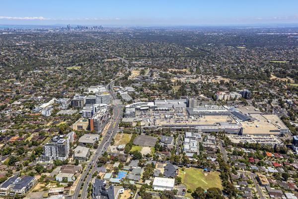
Doncaster Hill is a sustainable, high density, mixed-use village that provides for high quality urban living.
Located in the heart of Doncaster, Victoria, approximately 12kms from Melbourne's Central Business District.
Doncaster Hill is a sustainable, high density, mixed-use village that provides for high quality urban living.
Located in the heart of Doncaster, Victoria, approximately 12kms from Melbourne's Central Business District.
An activity centre for our community.
We’re continuing to update Doncaster Hill to improve the way our community lives, works and enjoys this neighbourhood.
These works form a part of our infrastructure planning for this area and the long standing Doncaster Hill Strategy.
The concept design for Hepburn Reserve has been developed in response to community feedback and will include outdoor seating, a BBQ area, a drinking fountain, public art, large open lawn areas, a playspace, nature play, canopy tree planting, bike hoops and more.
This small local open space was upgraded in November 2019 to December 2020
New U-turn lane on Tram Road
Pedestrian signals at the Applewood Retirement Village
Extension to Hepburn Road
Tram Road and Merlin Street intersection traffic lights
With populations on the rise in Melbourne, Doncaster Hill is one of our solutions to meet the challenge of future housing needs. This modern urban village allows those of us who enjoy to live in the suburbs to continue to do so, whilst providing apartment-style living for others.
The Doncaster Hill Strategy helps guide us on the land use and development in this centre.
Many bus routes that are provided by Public Transport Victoria (PTV) travel through Doncaster Hill.
View the routes and timetables of the following bus services:
SmartBus
Local services
In addition to bus services, we are strongly advocating for alternate public transport options with the State Government:
Find out why we are reviewing our strategic vision
Use this toolkit to assist your developments in Doncaster Hill
Stormwater that falls on a property is collected and drained to what is usually the lowest point on the property, which is known as the ‘legal point of discharge’.
This collected stormwater is then ‘discharged’ or released to the Council stormwater system, which is usually an underground drain in the street or in a property easement.
If no underground drain is available, the stormwater is drained to the ‘kerb and channel’ in the nearby street.
In some cases, the property owner will be required to construct a new drain to connect with the Council’s stormwater system. This is known as the 'point of connection'.
The property owner is responsible for the construction and maintenance for all drains, including drains outside of the property boundary, up to the Council’s stormwater system.
A legal point of discharge (POD) can be one of the following.
A POD is usually:
Before any issuing of a building permit, you must get a POD report for any work that has a drainage system. This will help a building surveyor make sure that the design of the internal drainage system is:
An application for a POD is a requirement for developments that include stormwater drainage systems.
You may also need to obtain a legal point of discharge report, if you are preparing Engineering Plans for our approval.
The cost for the POD is $155.35
You can apply online for a LPOD.
After submitting your application fee, we’ll email you with the relevant details within 10 working days.
The Legal Point of Discharge Report will provide information on:
The report does not contain information regarding the existing private stormwater system on the property or the existing point of connection.
Contact us to cancel your application
A vehicle crossing is sometimes known as a driveway that is on Manningham land.
If you are planning on doing any of the following works to a vehicle crossing, you will need a permit:
A vehicle crossing permit is to make sure you complete the works to the standards we require. A permit also ensures the works are safe.
If you are planning to do works to a vehicle crossing, you will need to get a permit. An applicant can be:
The person who gets the permit is responsible for the works.
The permit application process takes approximately 10 to 15 business days. The approved permit is valid for 6 months from the date of issue.
The cost for an application is $315.
For any required re-inspection a fee of $182 applies.
You will receive an invoice after an initial assessment. You do not need to pay upfront.
You can pay using our online service. Just use the permit reference number VC or other payment options outlined on the invoice.
Include as much detail as you can in your application and can include basic plans. This helps us understand what works you are doing.
After receiving your application, we will complete an assessment and prepare the permit conditions. We will contact you to discuss any problems with the proposed works.
You will receive an invoice for the application fee after submitting your form. You will get the invoice within 10 business days.
If there’s no issues, you will receive your permit a couple of days after paying the invoice.
For complex vehicle crossing works, the approval process may take longer.
To apply, download the application form and email it to us.
Once we have received your application form, this is the approval process:
We will inspect the property and check the details of the proposed works.
We will contact you if there are any issues.
If there are no issues, we will send you an invoice for the permit fee.
After paying the permit fee, we will send you the approved permit.
You can start the works after receiving the approved permit. You will have 6 months to complete the works.
We require you to book an inspection of the vehicle crossing works. You can find the inspection details on the approved permit.
After completing the works, we will check the finished product.
We will contact you to discuss any issues with the completed works.
We reserve the right to revoke permits at any time. We may also allow an extension before the permit expires. Extensions are generally only for a couple of weeks and are not always approved.
The vehicle crossing must conform to our standards, specifications and requirements. We will supervise the construction.
Vehicle crossings must be a minimum of 3 metres and a maximum of 4 metres in width, with 6 metre widths maximum in special circumstances. Unless, approved as part of a planning permit. You will find the exact details of approved works in the permit.
The number of vehicle crossings and widths of vehicle crossings allowed per property are in the table below.
|
Property frontage
|
1 vehicle crossing
|
2 vehicle crossings
|
|---|---|---|
|
0 metres to 15 metres
|
3 metres only
|
Not permitted
|
|
15 metres to 30 metres
|
3 metres to 4 metres
|
Not permitted
|
|
30 metres to 60 metres
|
3 metres to 4 metres
|
3 metres each
|
|
60+ metres (rural area)
|
3 metres to 6 metres
|
3 metres to 4 metres each
|
Contact us if you want to cancel your application.
If our existing drainage system can’t cope with an increase of runoff, an onsite drainage (OSD) system is a requirement of the planning process.
An OSD system helps retain stormwater onsite during heavy rainfall and releases water slowly through a constrained outlet. This limits peak discharge from the site.
Local developments that have the potential to increase stormwater runoff will generally need an OSD system.
The cost will be $550 to $1250. We base our fees on the number of units or apartments proposed on the plan.
Extra costs apply if you need to make changes to your OSD plans.
Download the OSD Design checklist and OSD guidelines.
Make sure you complete the design checklist correctly and that it is signed before submitting your OSD plans or OSD amended design plans.
Apply online by selecting 'Apply now' below.
You will need to complete an OSD amendments application to make changes to existing engineering plans. You will need to complete the application for constructing an outfall drain and for general drainage works. You will also need to submit revised engineering plans for re-approval and we may need to reinspect the site.
The cost will be $312 to $880. We base our fees on the number of units or apartments proposed on the plan.
We will notify you that we have received your application.
We will send you an email once we have approved your plan. This can take between 4 to 12 weeks. We may ask for more information in the meantime.
Once we have all the required information, we will assess your designs to check they are consistent with the legal point of discharge.
After receiving approval of an OSD system, you will also need approval to connect to our drains. The works and drainage permit is a requirement to connect into our drains and to do works on our road reserves or an easement.
Apply for a works and drainage permit
Ask us to inspect your complete OSD system so you can be sure it complies with the approved designs.
Depending on the changes you need to make, we may charge you for another inspection.
We can only sign a Certificate of Occupancy after the OSD system passes inspection.
You can install drainage infrastructure to service your property.
Any stormwater management system shouldn’t cause adverse effects on nearby properties.
Contact us for advice.
Contact us to cancel your application.
You will need an asset protection permit for any building work that can potentially damage or destroy Manningham assets. These include:
The permit helps us monitor potential damage. This keeps people safe and authorises us to make sure damaged public assets are fixed.
All building activities and projects require a building permit including:
An applicant is any person or company who is responsible for the works. They will be responsible and liable for any damages and repairs required to the satisfaction of Manningham. The permit also protects the applicant from paying for any damages present prior to the commencement of building work.
A property owner or an applicant may be breaching local laws and can receive an infringement notice or penalty if they don’t obtain a permit. Enforcement actions can also lead to legal prosecution and the Magistrate’s Court will determine the punishment.
If you are an owner or builder, you must obtain a permit at least 10 business days before the commencement of any works.
Applications take about 10 business days to process. A permit will only be issued once the permit fee and bond have been paid.
A non-refundable permit fee is $425 plus a security bond determined by the works and land.
A non-refundable permit fee will range between $600 and $20,000 plus the required security bond. The amount payable will depend on the scope and value of the development. The permit fee will be determined by the City Infrastructure manager.
Our asset protection officer will determine the security bond after an initial site inspection. We will make a security bond determination after a site inspection. The amount will range between $1000 and $20,000. The amount will consider the nature and extent of the works.
Commercial developments of works that pose a higher risk to our assets may incur a bond greater than $20,000.
If there is no damage or the applicant repairs any damage after the completion of building work, the applicant will receive a refund for the security bond.
A bond may be used to remedy:
It is the responsibility of the applicant to repair damage caused by other authorities before receiving a security bond refund. If we are required to repair any damages that exceeds the bond amount further charges may apply. The applicant will receive a separate invoice in such an event.
The fee increase covers road asset administration and associated inspection costs of the permits.
We will send two separate invoices to you for the asset protection fee and the required bond.
Pay your application fee online using the APR number.
Pay your security bond online using the BND number.
We’ll issue a permit and send it to you.
If you are no longer doing any work requiring an asset protection permit, contact us to cancel your application or permit. If you have already made a payment, a decision will be made on any applicable refund.
If you are conducting works or events on or near the road, it is important to ensure that:
If you are planning to conduct works or events that’ll impact traffic on our roads. This includes impacts on pedestrians, cyclists and general traffic, you will need to ensure that:
You will need our consent if you require traffic control devices such as bollards or signage to manage traffic around your works or event.
Works managers working for utility companies and public transport operators are pre-authorised to erect traffic control devices and don’t need our consent under traffic management regulations.
Submit your application at least 10 business days before your planned works. This lets us process your application on time and also allows us to review and amend an application if required.
Fees apply for all applications.
After receiving your application, we will review your Traffic Management Plan and provide you with an invoice listing your payment options.
To apply for consent you'll need:
Depending on your proposed traffic management and the impact on the road network, you may also need other documents, such as a detour plan or aftercare plan.
If your works or event impacts a Department of Transport (DoT) arterial road or requires major traffic control devices we can’t authorise, you’ll also need a Memorandum of Authorisation from DoT. You can find more info on DoT’s website.
We will require confirmation DoT has approved any traffic management on their roads.
After preparing your application, send the completed form with all necessary documents to us via email.
This application is only for consent to erect temporary control devices. Depending on your works, you might need other approvals.
Allow 10 business days for us to review your application and for any amendments that may be necessary. We will contact you if we need further information or amendments to your application.
Contact us to cancel your application.
Along with VicRoads, we maintain roads and footpaths in Manningham to make sure they are safe and functional.
If you find an issue with one of our roads or footpaths, you can report it to us. We'll let you know if it's our road or VicRoad's.
Check what type of road or footpath you can report and where you can report it. If unsure, contact us.
Types of repairs we perform
You can make a report online, in person or over the phone.
If the area is presenting an immediate danger, we will make it safe within 24 hours.
We will attend and repair the issue.
We will maintain the area in line with our footpath maintenance schedule.
You need an access across reserves permit to get access to private property through an adjoining Council reserve or Council property for any building works or similar.
There are some reasons where we may not issue a permit depending on:
The property owner and/or their contractor can apply for this permit.
The application fee is $156.00 (non-refundable)
You will also need to pay a refundable security deposit (minimum $250 to $2,000+)
To apply for consent you will need:
Allow 14 business days for us to review your application.
The following process once we receive your application:
We will advise you by email if your application is approved or not. If approved, we will issue a tax invoice for both the permit fee and the security deposit.
The permit will be sent to you by email.
We may revoke the permit if conditions are not met and an infringement may be issue.
Contact us to cancel your application.
Alan Morton Reserve is a linear reserve along a natural drainage line that runs alongside Park Road. It aids the pedestrian links to the Park Orchards centre from the south. ...
Alan Morton Reserve is a linear reserve along a natural drainage line that runs alongside Park Road. It aids the pedestrian links to the Park Orchards centre from the south. The Reserve is located within the Rainbow Valley Road, Biosite 20 and is considered a very high priority in Council’s Healthy Habitats Bushland Management Strategy 2012.
The Alan Morton Reserve Concept Plan was developed in 1995 and includes a wetland system to filter storm water runoff. As part of the Park Road upgrade in 2011, a shared path was constructed through the Reserve from Kebun Court to Enfield Avenue.
Have you noticed something unsafe like a broken tree branch or damaged playground that needs our attention?
Some types of events, such as festivals or school's cross country runs need a special permission to be held on public land.
Head down to Wonga Park Reserve for this free Tai Chi session. ...
Join the team from the Wonga Park Community Cottage for a free Tai Chi session.
The session will be held at Wonga Park Reserve (weather permitting) or at the Wonga Park Community Cottage.
This session is for females aged 20 plus. No experience required.
What to wear: clothes that allow movement
Wonga Park Community Cottage is celebrating This Girl Can by helping inspire women of all ages and abilities to get active however, wherever and whenever they choose, without being judged.
View and download the full Council Paper below. A clearer version of the Attachments can be viewed separately by clicking on the item below. ...
Meeting Date: 13 September 2016
Meeting Time: 7.00pm
Location: Council Chamber, 699 Doncaster Road, Doncaster
View and download the full Council Paper below. A clearer version of the Attachments can be viewed separately by clicking on the item below.
This a large (5,169m²) park located at the end of Aird Court south of Wonga Park Reserve and with the large mature trees, provides a lovely excuse to go for a walk. There is a natural drainage line through the Reserve. ...
This a large (5,169m²) park located at the end of Aird Court south of Wonga Park Reserve and with the large mature trees, provides a lovely excuse to go for a walk. There is a natural drainage line through the Reserve.
Have you noticed something unsafe like a broken tree branch or damaged playground that needs our attention?
Some types of events, such as festivals or school's cross country runs need a special permission to be held on public land.
Valepark Reserve is a great local park. Close to two local primary schools and next door to Donvale Retirement Village, Valepark Reserve also links residents to Cat Jump Park and the Mullum Mullum Creek Linear Park. ...
Valepark Reserve is a great local park. Close to two local primary schools and next door to Donvale Retirement Village, Valepark Reserve also links residents to Cat Jump Park and the Mullum Mullum Creek Linear Park.
Upgraded in 2014, improvements included new play equipment and a new pathway from the Donvale Retirement Village gate through the reserve.
The highlights of a visit to Valepark Reserve are the trampolines, the first in Manningham and the hammock swing. There is also a full sized swing, monkey bars and a long wave slide.
Suitable age group: all ages
Mullum Mullum Trail - 860 metres
Dellview Playspace, Mullum Mullum Creek Linear Park - 700 metres
Cat Jump Park - 600 metres
Cameron Reserve - 600 metres
Landscape Reserve - 1000 metres
Pine Hill Reserve - 1100 metres
Route 282 - Manningham Loop stops nearby in Carbine Street
Have you noticed something unsafe like a broken tree branch or damaged playground that needs our attention?
Some types of events, such as festivals or school's cross country runs need a special permission to be held on public land.
Websters Reserve is a very small reserve located in a low density residential area. The Reserve is located within 250 metres of Yarra Valley Parklands (Candlebark Park) to the west and 900 metres of Mullum Mullum Creek Linear Park (Tikalara Park) to the west. ...
Websters Reserve is a very small reserve located in a low density residential area. The Reserve is located within 250 metres of Yarra Valley Parklands (Candlebark Park) to the west and 900 metres of Mullum Mullum Creek Linear Park (Tikalara Park) to the west.
Have you noticed something unsafe like a broken tree branch or damaged playground that needs our attention?
Some types of events, such as festivals or school's cross country runs need a special permission to be held on public land.
Fitzsimons Reserve is a large 78,237m2 (7.8 hectares) habitat corridor between Westerfolds and Candlebark Parks on the Yarra River. It forms part of the Yarra Valley Parklands and protects flora and fauna, managed sympathetically with adjoining Parks Victoria managed Candlebark Park. ...
Fitzsimons Reserve is a large 78,237m2 (7.8 hectares) habitat corridor between Westerfolds and Candlebark Parks on the Yarra River. It forms part of the Yarra Valley Parklands and protects flora and fauna, managed sympathetically with adjoining Parks Victoria managed Candlebark Park.
Fitzsimons Reserve was the former site of Kiwanis Community Farm. A series of dams and wetlands, covering an area of approximately 4,000 m2, remain from this use.
Parks Victoria’s Main Yarra Trail goes through the western part of the reserve and skirts the southern side although informal tracks have been established along the river. By agreement, Parks Victoria manages the Main Yarra Trail and adjacent viewing platform within the reserve.
The site is also a popular launching point for canoes and kayaks, with a carpark and viewing platform adjacent to the river, overlooking rapids.
Have you noticed something unsafe like a broken tree branch or damaged playground that needs our attention?
Some types of events, such as festivals or school's cross country runs need a special permission to be held on public land.
Following the gradual easing of coronavirus (COVID-19) restrictions and Victorian Government advice, our parks, playspaces, outdoor fitness equipment and skate parks are now open for you to enjoy. ...
Following the gradual easing of coronavirus (COVID-19) restrictions and Victorian Government advice, our parks, playspaces, outdoor fitness equipment and skate parks are now open for you to enjoy.
The safety of our community is our top priority during this time. We have a regular cleaning and sanitising schedule in place for equipment in all of our parks in Manningham.
Please remember that you should not be gathering in groups of more than 20 people. We encourage everyone to continue practising physical distancing by staying 1.5 metres apart and maintaining good hygiene at all times.
Read more about the four play areas we have recently upgraded, which you can now enjoy with you children and families. And visit our website for more information about our parks and playspaces.
Manningham Council is inviting local residents to register their interest to be part of a new program where they can get involved and make their mark on their local park. ...
Manningham Council is inviting local residents to register their interest to be part of a new program where they can get involved and make their mark on their local park.
Parks Alive encourages local residents to get involved in improving their local parks.
The program will be unique to each park – it could include planning and carrying out improvements, organising community events, ongoing care and upkeep of local parks and much more.
Local Manningham resident and former VFL umpire, Glenn James OAM, is pleased to be the ambassador of Manningham’s Parks Alive program and is encouraging residents to register their interest and get involved.
“I love gardening and taking care of green spaces – this is a great program for Manningham residents. It’s a good way to get involved, do your bit and get to know your local community,” Mr James said.
Manningham Mayor Cr Andrew Conlon said there are plenty of ways to get involved in the new program.
“Parks Alive is an opportunity to help shape your local park. It could be planning and carrying out improvements, such as tree planting or setting up a community vegetable patch, helping to keep your park tidy and well maintained, organising community events and much more,” Cr Conlon said.
The first six parks to be enhanced as part of Parks Alive are:
To register your interest to get involved in Parks Alive or to nominate your own local park, visit manningham.vic.gov.au/parks-alive
Ruffey Lake Park’s Church Road North playground provides a different experience to the other playgrounds in the park. ...
Ruffey Lake Park’s Church Road North playground provides a different experience to the other playgrounds in the park.
Smaller and set amongst mature shade trees, the playground focuses on playing in the natural landscape and features a rock labyrinth, see-saw, swing suitable for all ages, junior see-saw and a cubby.
Cook something on the electric barbecues and enjoy a bite to eat in the large picnic shelter, or on the many picnic tables.
You can park the car in Church Road North.
Have you noticed something unsafe like a broken tree branch or damaged playground that needs our attention?
Some types of events, such as festivals or school's cross country runs need a special permission to be held on public land.
Manningham Council has a long standing commitment to Wonga Park and of recent years has committed significant resources and funding to upgrading recreation and community facilities. ...
Manningham Council has a long standing commitment to Wonga Park and of recent years has committed significant resources and funding to upgrading recreation and community facilities.
The work continues this year with four major projects (totalling $979,000) underway that will bring significant community health and environmental benefit, increase accessibility and capitalise on work previously undertaken at the Wonga Park Reserve.
Principle Pedestrian Network
As part of Council’s Principal Pedestrian Network, the footpath along the western side of Yarra Road is currently undergoing a significant upgrade (almost $300,000) to ensure better access from Launders Avenue (and Wonga Park Village shops) to Jumping Creek Road and beyond.
These works will also include a pedestrian refuge to enable safer crossing of Yarra Street and easier access to the school crossing on Jumping Creek Road which serves the Yarra Road Primary School students and parents.
Wonga Park Reserve in the spotlight again
Local sporting clubs will soon have greater access to the Wonga Park Reserve with work commencing on the installation of floodlighting.
More than $244,000 has been allocated to install floodlighting at the Wonga Park Reserve Oval No: 1 in Launders Avenue, which is the winter home to the Wonga Park Wizards Junior Football (Soccer) Club and the summer destination for the Wonga Park Cricket Club.
The No: 1 oval is used for multiple sports throughout the year, including cricket and soccer and the proposed lighting works will require that infrastructure is located outside of the oval perimeter to enable the current mixed use to continue.
The Wonga Park Reserve precinct is a wonderful community focal point and the new lights will be a great bonus for the clubs to increase their access to the reserve and offer more training programs and other opportunities that will help expand their membership base.
The installation of floodlights is a welcome addition to the reserve that also saw the pavilion extensively refurbished in 2011.
Wonga Park Tennis Club refurbishment
Manningham Council has commenced work on a $400,000 refurbishment to bring the Wonga Park Tennis Club clubrooms up to current standards and incorporate disability access in and around the building.
The refurbishment is being undertaken as part of Council’s Asset Maintenance Schedule (AMS) Program, with additional funding from the Wonga Park Tennis Club, a grant from Tennis Australia and a community grant from the Bendigo Bank.
The Wonga Park Tennis Club is a vital focal point in the local community and works such as these are about providing an accessible and socially connected facility, which in turn encourages a healthy and active community.
The refurbishment includes the:
Sewer connections on Council buildings
As part of the Sewer Backlog program, six Council buildings in Wonga Park are being connected to the sewer at a cost of $35,000. Work started in mid September and all the buildings are expected to be connected by mid-October.
The buildings connected are the:
This ride explores Ruffey Lake Park and the Ruffey Creek Linear Park. ...
This ride explores Ruffey Lake Park and the Ruffey Creek Linear Park.
There is a large sign marking the beginning of the Ruffey Trail at The Boulevarde in Ruffey Lake Park.
From here, a ramp takes the cyclist to an underpass at King Street and again at Williamsons Road.
Follow the Ruffey Trail signage until it finishes at Finns Reserve and joins the Main Yarra Trail.
At Finns Reserve, the Ruffey Trail connects with the following trails:
Main Yarra Trail to Westerfolds Park (northeast) and Southbank (southwest)
Plenty River Trail to Greensborough (Western Ring Road Trail)
|
Access |
|
|---|---|
|
Distance |
3 kilometres |
|
Grade |
Easy |
|
Surface |
Sealed paths with on road sections. Suitable for all bicycle types. |
Eumeralla Avenue is a local road which has no footpath or trail
Use the pedestrian refuge at the Foote Street on-road crossing. The Trail continues a short distance along Mclachlan Street and turn left onto Parker Street
There is an on-road crossing at Parker Street, Templestowe and the Trail picks up again next to the Templestowe Bowling Club carpark
Ruffey Lake Park - Adventure playgrounds, picnic shelters, BBQs, lake and wetlands, toilets and drinking water.
Finns Reserve - Picnic shelter, BBQs, playground, Yarra River access, toilets and drinking water.
Westerfolds Park - BBQs, picnic shelter, wetlands and Yarra River Observation Deck, toilets and drinking water.
Detour to Templestowe Village - cafes, restaurants, supermarket
Have you noticed something unsafe like a broken tree branch or damaged playground that needs our attention?
Some types of events, such as festivals or school's cross country runs need a special permission to be held on public land.